Update: Rafael Fire tops 62,000 acres; 11% contained
The Rafael Fire as of Sunday morning, June 27, 2021. (Courtesy)
Updated as of Sunday, June 27, 2021 10:04 AM
SUNDAY UPDATE:
For information on evacuation status, and fire activity, there will be a virtual community meeting every day at 6 p.m. until further notice, on the Incident Facebook page: https://www.facebook.com/RafaelFireInfo/.
RAFAEL FIRE
Acres: 62,376
Percent Containment: 11%
Date/Time Detected: Friday, June 18 at 1927 MST
Structures Damaged/Destroyed: 0
Number of Personnel: 664
Cause: Lightning
Origin/Location: 4 miles north of Perkinsville
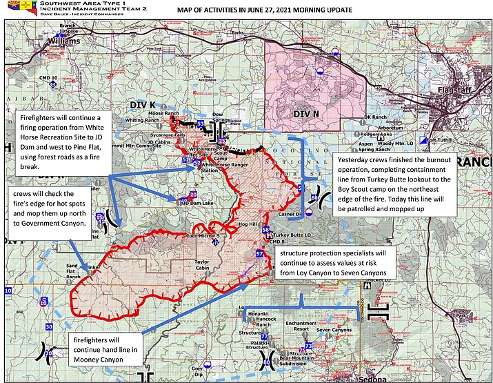
Saturday, crews finished the burnout operation, completing containment line from Turkey Butte lookout to the Boy Scout camp on the northeast edge of the fire. Today, this line will be patrolled and mopped up. This operation was designed to prevent movement of the fire to the northeast toward Flagstaff, and other values at risk. Firefighters will continue a firing operation from White Horse Lake Recreation Site to JD Dam and west to Pine Flat, using forest roads as a fire break.
Near the fire origin, crews will check the fire’s edge for hot spots and mop them up north to Government Canyon. On the south side of the fire, firefighters will continue hand line in Mooney Canyon, and structure protection specialists will continue to assess values at risk from Loy Canyon to Seven Canyons Resort.
Approximately 10 miles of burning is left to contain the north end of the fire and crews will attempt to complete that operation today if weather conditions allow.
Consequently, smoke is expected to be more noticeable, and may settle in low lying areas, such as Verde Valley and Prescott Valley, lifting by late morning. Smoke columns will be visible throughout the day as burning operations continue. Smoke forecasts are available at Wildfire Smoke Forecast | ADEQ Arizona Department of Environmental Quality (azdeq.gov) and https://fires.airfire.org/outlooks/NorthCentralArizona. Today a BAER (Burned Area Emergency Response) team will begin assessing fire impacts to soils and watersheds.
Evacuation status as of 6 a.m. June 27 (Notifications are in place until status is rescinded or changed by each respective County Sheriff’s Office):
“GO” in Coconino County Sycamore Canyon and in Yavapai County, Loy Ranch. American Red Cross (ARC) activated a shelter to support those who have been evacuated due to the fire. ARC Shelter is located at Sinagua Middle School, 3950 E. Butler Ave., Flagstaff, AZ 86004.
“SET” – in Coconino County, Garland Prairie South and Garland Prairie North. In Yavapai County, Grey Ranch, Windmill Ranch and Bear Mountain.
“READY” -– in Coconino County, South of Williams, Sherwood Forest, Camp Navajo, West of I-17 south of 1-40, Westwood Estates, Flagstaff Ranch (including W.L. Gore), Mountain Dell, Pine Del, Forest Highlands, Kachina Village, University Heights, Equestrian Estates, Upper Oak Creek canyon, West Fork, Lower Oak Creek canyon and in Yavapai County, Sedona.
It’s fire season in Northern Arizona. All residents in Northern Arizona should be in Ready status.
Information about evacuation status can be found on the Coconino County Facebook page at: https://www.facebook.com/CoconinoCounty and at the Yavapai County Sheriff’s Department Facebook page at: https://www.facebook.com/YavapaiCountySheriff/ Maps of evacuation status in Coconino County can be found at: Coconino County Situational Awareness Viewer (arcgis.com)
Full forest closures are in effect on the Kaibab National Forest, Coconino National Forest, and Prescott National Forest. Kaibab National Forest - Alerts & Notices (usda.gov). Coconino National Forest - Alerts & Notices (usda.gov)
Prescott National Forest - Alerts & Notices (usda.gov)
All Arizona State Trust lands are closed effective Friday, June 25 at 8:00 a.m. Fire Restrictions and Closures Across Arizona | Department of Forestry and Fire Management (az.gov)
SATURDAY UPDATE:
The Rafael Fire has spread to 53,664 acres as of 9 p.m. Saturday, with 11% containment, according to a Prescott National Forest news release.
As of Saturday morning, 664 firefighters were battling the blaze.
ROCK BUTTE FIRES
As of Saturday at 9 a.m., the Red Hat Fire, covering 49 acres, was 100% contained; the Limestone Fire, covering 33 acres, was 100% contained; the Spring Fire, covering 567 acres, was 75% contained; the Rock Butte Fire, covering 126 acres, was 56% contained; and the Silent Fire, covering 27 acres, was 100% contained. These fires are north of Paulden and west of Highway 89.
As of Saturday morning, there were 98 firefighters, four engines, two crews one bulldozer and two water tenders battling these blazes.
KAIBAB
Today on the Kaibab National Forest, firefighters will continue yesterday’s burnout, bringing fire south from the Sycamore Falls Climbing Area to White Horse Lake, with support of an unmanned aerial vehicle (drone).
Crews will continue line preparation from Pine Flat to Sycamore Point along FR 105, in anticipation of a firing operation.
COCONINO
On the Coconino National Forest, crews will mop up and patrol yesterday’s firing operation from the Boy Scout Camp to the intersection of FR 527 and FR 538.
Crews will continue the firing operation today down FR 538 to the edge of Sycamore Canyon.
This activity is designed to stop fire growth towards the values at risk in the Interstate 40 corridor from Williams to Flagstaff.
This afternoon, crews will begin to back fire down into Sycamore Canyon by aerial ignition with helicopters and drones. This activity is designed to minimize fire effects to soils and vegetation on the steep slopes of Sycamore Canyon.
BURNING OPERATIONS
Burning operations are expected to continue for the next few days as long as weather conditions allow. Smoke is expected to be more noticeable the next few days due to burnout operations.
Smoke may settle in low lying areas, such as the Verde Valley and Prescott Valley area, and will lift by late morning. Smoke columns will be visible throughout the day as burning operations continue. Smoke forecasts are available at Wildfire Smoke Forecast, ADEQ Arizona Department of Environmental Quality (azdeq.gov).
Information provided by Prescott National Forest.
Sign up for our e-News Alerts
SUBMIT FEEDBACK
Click Below to: