Firefighters battling Horse Fire install protection around Crown King homes
Fighting fire for full suppression; aircraft heavily used
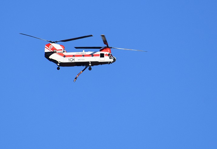
Helicopters and air tankers are being heavily used to fight the Horse Fire. The aircraft are working to install protection around Crown King homes and supplement on-the-ground firefighting. (Richard Haddad/Courier)
Updated as of Tuesday, October 20, 2020 8:02 PM
Acres: 9162 acres
Containment: 21%
Resources: 330
Vegetation: Juniper, chaparral and timber
Start Date: Oct. 15, 2020: noon
Cause: Human, under investigation
Origin Location: Seven miles northwest of Crown King; 18 miles south of Prescott on the Bradshaw Ranger District (T1N, R2W, S24)
CROWN KING — Area residents can expect to see a steady flow of aircraft fighting the Horse Fire near Crown King.
According to the Southwest Area Type 1 Incident Management Team, helicopters and air tankers are being heavily used to install protection around Crown King homes and supplement on-the-ground firefighting.
Incident Commander John Truett explained that the goal is full suppression and to protect all the communities near the fire.
"The Southwest Area Type 1 Incident Management Team is working to surround the fire and keep it out of the communities of Crown King, Minnehaha, Cleator, Black Canyon City, Groom Creek, Ponderosa Park, Walker, Potato Patch, Breezy Pines, Pine Flat, Lookout Mountain, Wilhoit, Wagoner, Walnut Grove, and Prescott," Truett wrote in a news release Monday, Oct. 21. "In addition, protection is important for critical infrastructure, including the Towers Mountain and Wildflower communication towers; APS power lines; Horsethief, Union, and Spruce Lookout Towers; and transportation infrastructure.
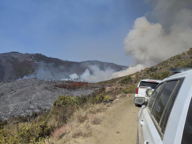
The Horse Fire burned actively Monday in the northeast corner of the perimeter from Blind Indian Creek to Pine Springs drainage and made short runs. Hotshot crews will aggressively work in this area on Tuesday.
In the Crown King community, crews continue to create firebreaks; sprinkler systems are in place in the center of town and areas homes, with crews expanding protection Tuesday to the southwest areas. The community of Crown King remains evacuated, the release said.
Along FR 52 (Senator Highway), the fire is moving slowly and predicted to hold in Pine Creek and north of Thompson Butte. Activity in the Ash Spring area continues to slowly move through dry vegetation. The southern half has cooled with heat deep inside of the fire perimeter. However, temperatures are above normal and dry and dead vegetation creates the potential for fire movement if wind hits from the correct direction. Warm and dry conditions continue through Wednesday.
GET ACCURATE INFORMATION
County officials cautioned residents about vetting sources of information during a fire or other disaster.
"During emergencies, it is of utmost importance to ensure information is accurate, timely and vital to the communities impacted," said Terri Farneti, public health coordinator for Yavapai County Community Health Services.
For the Horse Fire, the sources with the most up-to-date and accurate information are:
• The Yavapai County Emergency Phone Bank: 928-442-5103. Open 7 a.m. to 7 p.m.
• InciWeb: https://inciweb.nwcg.gov/incident/7244
• U.S. Forest Service - Prescott National Forest’s Twitter page, https://twitter.com/PrescottNF and Facebook, facebook.com/PrescottNF
• Yavapai County Emergency Management Facebook page, facebook.com/YCOEM/
• For those without Facebook access, you can visit the Yavapai County Public Works website to see the information feed regarding the fire, yavapai.us/publicworks/emergency-management
• Yavapai County Sheriff’s Office Facebook page, facebook.com/YavapaiCountySheriff
In addition, the Yavapai County Sheriff’s Office now uses CodeRED as its Emergency Notification System. With this service, authorities can send messages to residents and businesses within minutes with specific information when an emergency or time-sensitive issue arises. This is an essential service, especially during a wildfire. Sign up for CodeRed at, public.coderedweb.com/CNE/en-US/A45C10E5EC0F.
For evacuation assistance, contact the Red Cross at 1-800-842-7349. It is encouraged to contact them early in the day for arrangements to be made. Currently, there is no need for donations of any kind.
Information provided by Southwest Area Type 1 Incident Management Team and Yavapai County Community Health Services.
Sign up for our e-News Alerts
SUBMIT FEEDBACK
Click Below to: