Powerful hurricane could be headed to US
What to expect?
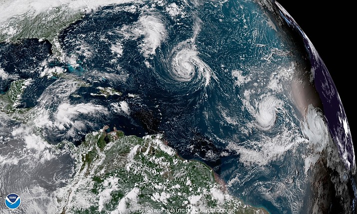
This enhanced satellite image shows Tropical Storm Florence, center, in the Atlantic Ocean on Saturday, Sept. 8, 2018 at 2:45 p.m. EDT. (NOAA via AP)
MIAMI — The U.S. East Coast could be hit with a powerful hurricane next week as Tropical Storm Florence continues to strengthen as it moves toward the mainland, forecasters said Saturday.
Florence is expected to become a major hurricane by Monday, the National Hurricane Center said, adding that "a significant phase of intensification" is expected late Saturday.
The Miami-based weather center said although the storm could intensify to a Category 4 hurricane by midweek, its path was still unclear.
"Florence is forecast to be a dangerous major hurricane near the southeast U.S. coast by late next week, and the risk of direct impacts continues to increase," the hurricane center said Saturday.
Officials in the Carolinas warned residents to prepare and to brace for impact.
Governors in both South Carolina and Virginia declared a state of emergency Saturday to give their states time to prepare for the possible arrival of the storm. South Carolina Gov. Henry McMaster emphasized that there's no way to know yet when and where the storm will hit land, or when evacuations might be called.
On Friday, North Carolina Gov. Roy Cooper declared a state of emergency and urged residents to use the weekend to prepare for the possibility of a natural disaster.
"We are entering the peak of hurricane season and we know well the unpredictability and power of these storms," Cooper said.
The U.S. Navy is making preparations this weekend for its ships in the Hampton Roads area to leave port. The U.S. Fleet Forces Command said in a news release Saturday that the ships will get ready in anticipation of getting under way Monday to avoid storm damage.
Adm. Christopher Grady said in a statement that the decision was based on Florence's current track, which indicates the area could see strong sustained winds and storm surges.
The news release notes that plans could change if forecasts indicate a decrease in the strength or change in the track of the storm.
Swells generated by Florence are affecting Bermuda and could cause dangerous rip currents and coastal flooding Saturday in areas including coastal Delaware and New Jersey, the National Weather Service said.
At 5 p.m. EDT, the hurricane center said Florence's maximum sustained winds were estimated to be 70 mph (110 kph). The storm was centered about 810 miles (1305 kilometers) southeast of Bermuda and moving west at 5 mph (7 kph).
With severe storms approaching US, what to expect?
Emergency officials are urging residents to prepare for severe storms that are forecast to hit the East Coast and Hawaii over the next week at what is the peak of this year's hurricane season.
Coming in from the Atlantic Ocean, Tropical Storm Florence is expected to make landfall Thursday as a level 3 hurricane or greater, steered by winds that could guide it as far south as Florida or as far north as New England.
Meanwhile, Hurricane Olivia is forecast to hit the Hawaiian Islands as a tropical storm on Wednesday, bringing heavy rains just two weeks after Hurricane Lane caused major flooding.
A look at what forecasters are predicting for those storms and the rest of the season:
WHAT DO WE KNOW ABOUT THE STORMS RIGHT NOW?
Tropical Storm Florence was gathering strength Saturday, with the National Hurricane Center expecting it to become a hurricane overnight. Five days out from expected landfall, there's still wide uncertainty about where it will hit and at what intensity, but the latest models show that it's most likely to make landfall in the southeast U.S., between northern Florida and North Carolina.
Still, there's a chance it could be pushed farther north and strike along the mid-Atlantic or New England coast, threatening to make landfall between Virginia and Massachusetts. No matter where it lands, there's a chance it could stall out and pummel the coasts for days.
The latest models on Saturday show that it's becoming less likely the storm will veer north and miss the mainland U.S. entirely. At minimum, residents along the East Coast are being told to expect heavy rainfall and storm surges, with the possibility of heavy winds.
Forecasters are also keeping an eye on two storms gathering behind Florence. Tropical Storm Helene was expected to reach the Cabo Verde islands on Saturday but is predicted to miss the mainland U.S. A tropical depression that was upgraded to Tropical Storm Isaac on Saturday is headed toward the Caribbean and brings a greater chance of curving north toward Puerto Rico and the mainland, potentially as a hurricane.
It's still uncertain whether Hurricane Olivia will make landfall in the Hawaiian Islands, but at minimum meteorologists believe it will come very close and deliver a new round of rainfall.
The National Weather Service has also issued a typhoon watch in the U.S. territory of Guam, where Tropical Storm Mangkhut is approaching from the east and is expected to bring damaging winds by Monday evening.
WHEN WILL WE HAVE A BETTER IDEA OF WHETHER THEY POSE A THREAT?
Each day brings a clearer picture of the risks posed by the storms. Jeff Masters, co-founder of the Weather Underground service, says airplanes gathering weather information began flying into Florence on Saturday, which should provide data that will lead to a major boost in the reliability of models on Sunday.
Isaac's route is still wildly uncertain and will be for days. Forecasters are more confident that Olivia will affect Hawaii, with its path and intensity sharpening in the next few days.
WHAT FACTORS GIVE FLORENCE A CHANCE OF BEING A PARTICULARLY STRONG HURRICANE?
By the time it reaches the East Coast, Florence could strengthen into a major hurricane. Winds higher up in Florence have been weakening, giving it time to gather itself and gain strength over the ocean, experts say. And it's also approaching water where the temperature is slightly warmer than average, providing heat that the storm can convert into stronger winds.
HOW SHOULD PEOPLE IN AREAS VULNERABLE TO HURRICANES STAY PREPARED?
Residents in evacuation zones are urged to have a plan to flee if the order comes. Others should have at least a week's supply of food, water and medication for their families and their pets.
Brian McNoldy, a senior researcher at the University of Miami's school of marine and atmospheric science, says residents who stick it out should have gas cans to fuel their cars and power generators, and should take out some cash in case electronic payment systems are down after the storms pass.
To avoid a headache down the line, residents are also encouraged to keep insurance documents in a safe place ahead of time.
North Carolina's governor already issued a state of emergency on Friday as the storm advanced, while officials in other coastal states say they're monitoring forecasts.
WHAT EXPECTATIONS DO FORECASTERS HAVE FOR THE REST OF THE HURRICANE SEASON?
The second week of September is the peak of hurricane season, so the flurry of activity is no surprise to forecasters. After the current round of storms, though, long-range models suggest a lull for several weeks.
Masters said there's a chance for another active period by mid-October, which would mark the end of the busiest stretch of the season.
"I don't think we're quite done yet," he said, "but certainly as far as September goes, this is the big week."
Sign up for our e-News Alerts
SUBMIT FEEDBACK
Click Below to: